

Collected for you...
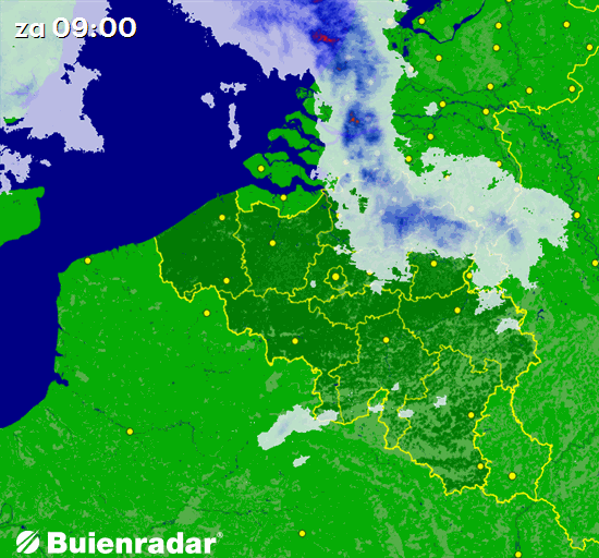
Precipitation and rain radars...
Precipitation and rain radars...
Rainradar is very reliable, but for extra certainty, it is best to always check the date and time on the map.
Rain radar...
Scroll down for other special radars and additional metrology links...
Metrology website links, etc...
Become a weather forecaster yourself thanks to the collected rain radars and other interesting links:
Lightning radar Europe
Live map view https://map.blitzortung.org/#4.22/48.95/5.02
Live map view https://map.blitzortung.org/#4.22/48.95/5.02
Lightning radar Belgium live:https://lmaps.org/#4.74;50.59;8
Boot tracker
Follow shipping traffic live, in case of hurricane, storm or other dangers you recognize which dangerous zones in shipping traffic should be avoided https://www.vesselfinder.com/nl
Follow shipping traffic live, in case of hurricane, storm or other dangers you recognize which dangerous zones in shipping traffic should be avoided https://www.vesselfinder.com/nl
EumetView
Here you can also recognize the shifts of the hidden lower or upper air pressure areas etc.
https://view.eumetsat.int/productviewer?v=default
Here you can also recognize the shifts of the hidden lower or upper air pressure areas etc.
https://view.eumetsat.int/productviewer?v=default
Flightradar. Follow air traffic live. In case of hurricanes, storms and other dangers, you can identify which dangerous thunderstorm zones to avoid in air traffic. https://www.flightradar24.com/50.72,3.05/7
Geologische kaart. Zoom in or out and use the color code to identify the deep valleys in the countryside or the highest hills and mountain peaks in the Ardennes.
https://nl-be.topographic-map.com/maps/grhh/Belgi%C3%AB/
https://nl-be.topographic-map.com/maps/grhh/Belgi%C3%AB/
Geoloket province of Antwerp. Discover the flood-prone areas in Antwerp. Waterways, buffer zones in built-up areas and beyond.. https://geoloket.provincieantwerpen.be/geoloketten/?viewer=extern&LayerTheme=2
Hurricane tracker https://www.nhc.noaa.gov/cyclones/?atlc
KMI Royal Meteorological Institute of Belgium https://www.meteo.be/nl/belgie
Seismology,, Recent earthquakes Belgium/Netherlands. https://seismologie.be/nl
Seismology and Volcanic Eruptions Live World Map, https://earthquakes.volcanodiscovery.com/?L=15
Seismology, World Map.https://www.noodweer.be/actuele-aardbevingen-wereldwijd/
Snow depth Belgium webcam KMI https://www.meteo.be/meteo/view/nl/13115388-Webcams.html
Starlink satellite maphttps://satellitemap.space/
Satellite map 3D https://satellitetracker3d.com/
Traffic Center Live highway images You can also recognise dry or wet road surfaces via the camera images from the traffic centre http://www.verkeerscentrum.be/verkeersinfo/camerabeelden/antwerpen
Water levels Flanders Waterway sensors, streams, Waterinfo Flanders.
https://www.waterinfo.be/Themas#item=getij/actueel
https://www.waterinfo.be/Themas#item=getij/actueel
Water levels Wallonia; watercourses, rivers, waterways, sensor measurements, etc..
http://voies-hydrauliques.wallonie.be/opencms/opencms/fr/hydro/Actuelle/crue/index.html
http://voies-hydrauliques.wallonie.be/opencms/opencms/fr/hydro/Actuelle/crue/index.html
Windy live wind map with webcamhttps://www.windy.com/?50.460,4.396,8
Zoom.earth Hurricane tracker and route forecast https://zoom.earth/maps/satellite/
Shadow world map See where the shadow falls at the chosen time and date.
Ideal if you're going on holiday and your hotel or campsite is in a sunny area, or not.
You don't want to sit in a shady valley all day, do you?
https://shademap.app/@51.2198,4.4671,15z,1744192650197t,0b,0p,0m
View the map, and set it to your preference...
Ideal if you're going on holiday and your hotel or campsite is in a sunny area, or not.
You don't want to sit in a shady valley all day, do you?
https://shademap.app/@51.2198,4.4671,15z,1744192650197t,0b,0p,0m
View the map, and set it to your preference...
Rain radars , etc...


Website in Flemish - Dutch
Click here
Click here